
Searching Wyoming County Property Records
Wyoming County property records live in linked county and state systems, and each piece answers a different question. Begin with the Assessor's free property search when you hold a street address, an owner name, or a map and parcel value. That single result can return the tax district, legal description, current owner, mailing address, assessment figures and a deed book and page. The deed reference is the bridge. It leads straight to the County Clerk's recorded instrument. Payment questions belong to the Sheriff's Tax Office instead. Location questions call for a map.
Compare the assessor card with the Landmark tax map or the statewide WV Property Viewer when boundaries matter. The tax roll describes a parcel for assessment. The clerk's deed records a conveyance. The map shows a tax-based view of location. A fresh deed may lag behind the assessor card. Remember the limits: a map line is not a survey, and a recorded deed is not a title opinion.
- Search the Assessor's public portal with the owner's name, parcel address, account number, district, map and parcel, legal description, or deed book and page.
- Open the parcel card and note its CURRENT OWNER, MAILING ADDRESS, situs, legal description, and deed reference.
- Use the book and page or party names to ask the County Clerk for the recorded deed and related filings.
- Check the Sheriff's tax office for a ticket or the State Auditor's delinquent-land database for certified-to-state status.
- Compare the parcel on the tax map, then request a survey or certified copy from the proper custodian when precision matters.
Wyoming County Record Custodians
No single Wyoming County office holds every part of a property file. The County Clerk records deeds, trust deeds, releases, plats, liens, wills and probate material. The Assessor keeps the ownership and valuation roll and ties it to the tax maps. Tax collection falls to the Sheriff's Tax Office, which also serves as county treasurer. Circuit cases involving foreclosure, quiet title or partition sit with the Circuit Clerk, though the conveyance itself still lands in the County Clerk's land records. Knowing the split saves a trip.
Wyoming County Clerk
Courthouse, Bank and Main streets
P.O. Box 309, Pineville, WV 24874
(304) 732-8000
Wyoming County Assessor
County courthouse offices
Pineville, WV
Call the courthouse at (304) 732-8000
Wyoming County Sheriff's Tax Office
24 Main Avenue
Pineville, WV 24874
(304) 732-8004
Wyoming County Assessor Search Fields
The Assessor's form is more flexible than a plain address box. Its help page notes that blank fields are ignored. Entered criteria are combined. For older rural addresses, try the street name alone and drop the number. Owner names go last name first, with no comma. Map and parcel fields accept local components, and the system fills in leading zeros or spaces as needed.
| Search field | Use in Wyoming County | Format note |
|---|---|---|
| Owner Name | Find parcels tied to a person or entity | LAST NAME FIRST NAME, no comma |
| Parcel Address | Start from a situs street address | Street-only search may work better |
| Account # | Open an exact assessment account | Use the known account value |
| District and Map/Parcel | Match a tax map identifier | Local form normalizes zeros and spaces |
| Legal Description or Deed Book/Page | Search a lot name or clerk reference | Enter the recorded wording or reference |
The Wyoming County Assessor help page explains that blank fields are ignored. Names use last-name-first order. A street alone may work better than a guessed rural number. The office publishes no online-year cutoff for its roll. Ask about older material the search may not return. Check the tips before entering an uncertain address.
View the official Wyoming County search tips whenever an owner spelling or rural address proves tricky.
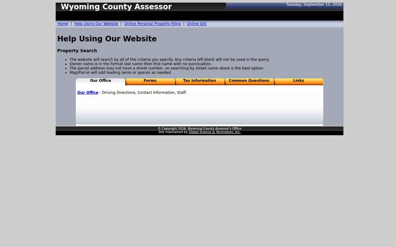
Local formatting rules can turn a blank result into a useful parcel match. The help page spells out those rules in the county's own terms.
Inside a Wyoming County Parcel Card
The parcel card joins tax, location and deed clues on one record. CURRENT OWNER is the name the assessment roll uses. MAILING ADDRESS shows where notices go. This can be a P.O. box, company, trustee or agent. Street Address marks the situs. Legal Description may name a lot or describe a tract. The deed book and page point to a County Clerk record. Sales History and Assessment Record organize the value side.
The Assessor's parcel-card layout also lists taxing district, land and property factors. Items like topography, utilities, road, traffic, land use, frontage, location and fences appear there too. These are assessment clues, not a formal appraisal. Note the account or Map/Parcel before moving between systems, since similarly named owners invite mix-ups.
For live lookups, open the Wyoming County Assessor search page. Compare its fields with the help instructions before typing a rural address. The parcel key it returns travels with you. Carry it into a deed, tax bill or map search.
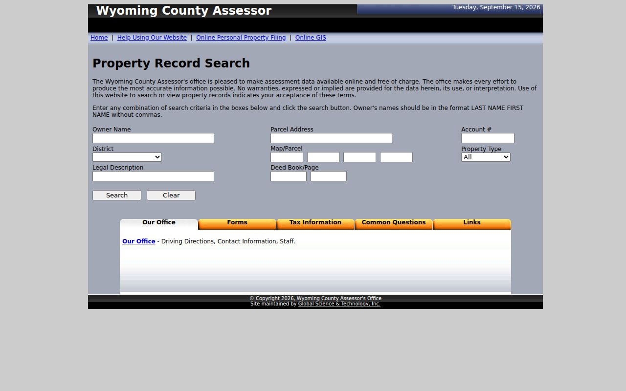
The form shows the county's own search vocabulary. Carry the returned parcel key into any deed, bill or map lookup that follows.
Wyoming County Deeds Since 1850
Wyoming County was carved from Logan County in 1850. Its first court met near Oceana that June. A courthouse went up there in 1851. The seat later shifted to Pineville in 1907. That move brought a temporary frame courthouse in 1908, a stone building in 1916 and an annex in 1958. Those place names can sharpen an old deed search. No confirmed courthouse fire or lost land-record decade appears in the county's accounts.
Wyoming County's published history covers the seat change and the courthouse sequence in detail. The FamilySearch catalog lists Wyoming County deeds from 1850 through 1902. It also lists a deed index running to 1969. Catalog ranges describe holdings, not a promise that every page image is viewable online. The County Clerk can confirm which books, indexes and copies exist today. The 1907 seat move also makes Oceana and Pineville useful terms in newspapers. They help in family-history searches too.
Place names are only a starting point. Deeds themselves are indexed by grantor, grantee and legal description. A search built on parties and land descriptions will travel farther than one built on geography alone. Ask the Clerk's office before assuming a record is missing.
Wyoming County Tax Maps and Taxes
The Assessor's map link opens Landmark Geospatial. Its notice spells out limits that matter. Tax maps serve assessment purposes only, not surveys or legal documents. They cannot be used in court. They may not be current or fully accurate. It also restricts copying of finished tax maps. So treat the viewer as a wayfinding tool: orient yourself, read district and parcel labels, and locate a map sheet. For a legal boundary, rely on a recorded plat or a licensed survey.
The portal's warning loads before the viewer opens. Read it as part of the record's limits, especially on sloped ground, where a drawn polygon can look more exact than the deed calls. Keep each question with the right specialist: the deed or recorded plat carries the written parcel description, while the county tax display is a working aid for assessment and navigation.
Wyoming County's 60 Percent Assessment Rule
West Virginia generally assesses property at 60 percent of fair market value. The math is simple. A $100,000 market example yields a $60,000 assessed value. The assessment date is July 1. Assessors physically visit real property once every three years and adjust annually when a change appears. A tax card reports an assessment year; a deed records a transfer event. Those dates do not mean the same thing.
Class II covers owner-occupied homes and certain farm property. Class III generally covers property outside municipalities. Class IV applies inside municipalities, except property already in Class II. Nearby lots can sit in different levy contexts, so compare both class and taxing district. State and local material lists tickets issued on or after July 15, installments due September 1 and March 1, a 2.5 percent early-payment discount, and delinquency after October 1 or April 1. Check the current bill with the Sheriff's Tax Office.
Wyoming County Town and City Records
The county lists three incorporated municipalities: Mullens, Oceana and Pineville. Their local files add permits, zoning, council actions, streets and public works, but none replaces county land records. Mullens has a railroad and coal-valley history; Oceana was the early county seat; Pineville became the seat after the 1907 move. Mail ZIP, municipality, taxing district and deed description should be kept as separate clues.
The official county communities roster names municipal contacts and links to local services. Oceana's site advertises permits, zoning and inspections, though no public searchable field list was found. The town code describes Residential, Mobile Home and Commercial districts, including Route 10 frontage and Routes 85 and 971 provisions. Ask Town Hall about a specific parcel rather than infer zoning from a map color.
Wyoming County Historical Deed Index
The County Clerk's record room sits on the ground floor of the courthouse near Bank and Main streets in Pineville. Mail goes to P.O. Box 309, Pineville, WV 24874, and the office lists (304) 732-8000 with weekday hours of 8 a.m. to 4 p.m. One phone call settles whether a needed 1850-1902 book is held locally, available through a catalog, or requires a copy request.
Wyoming County formed from Logan County in 1850. The FamilySearch catalog lists county deeds from 1850 through 1902 and a deed index from 1850 through 1969. Those ranges describe a research collection, not a promise that every image opens online today. The County Clerk's current page identifies the local land-record office, but the office publishes no live grantor-grantee search and no online cutoff date.
A deed chain starts with the current card's book and page. Then ask the Clerk which index and original book cover the date. Anything before 1850 may fall under the former Logan County jurisdiction. The courthouse seat moved from near Oceana to Pineville in 1907, so a place name in a family note may not point to where the modern record sits. Parties and the legal description guide the request best.
Wyoming County Delinquent-Land Records
Tax tickets and delinquent-land listings are different records. The Sheriff's Tax Office handles county collection and lien-sale questions. The State Auditor's Certified-to-State search covers land sent to the state after delinquency. Its form can narrow the field. Filters include tax year, county, district, map, parcel, taxpayer, purchaser, certificate number, ticket, account and status.
Treat a delinquent result as a status lead. It is not a deed. It is not proof that title changed. Before concluding anything about a parcel, compare the original ticket, any later payment or redemption, the Clerk's subsequent deeds and the assessment card description. Ask the local tax office. Confirm the tax year and parcel key. That matters when a lot has been split or its map number changed.
State guidance says a tax-sale payment is made by check or money order payable to the county sheriff, delivered before close of business on sale day. That detail is for a purchaser following a current notice, not an ordinary bill payment. Before acting, check the Wyoming County Sheriff's current sale notice, ticket year and redemption status.
Wyoming County Owner and Mailing Fields
An assessment card answers three different questions at once. The CURRENT OWNER field names the owner of record for tax purposes. The situs address shows where the parcel sits. The mailing address often does neither, since it may hold a P.O. box, a business, a trustee, or an agent. It cannot place the property on a map. A statewide assessment screen can also display one owner while the deed names several co-owners.
So a single screen is never a title opinion. For a Wyoming County transfer, start with the deed book and page tied to the parcel. Compare the legal description with the assessor's map. Ask the Clerk for filings when a deed lists several grantees or a later release changes an interest. The assessment roll serves navigation and taxation. The recorded instrument itself remains the record to examine.
Name searches follow a local rule. Enter a person's last name first, with no comma, as the help page directs. For a company or trust, copy the exact spelling. A state business record serves only as a separate identity clue. A tax card's public owner field is a starting point, not a directory of residents or a full account of every beneficial interest.
Wyoming County Property Records by Type
Each Wyoming County property record has a custodian and a narrow job. Use a deed to verify a conveyance. Use the tax card for the assessment. The tax ticket shows charges and payment. Turn to the map for spatial context, and weigh permits or court files as background that never replaces the instrument in the deed books.
| Record Type | What It Documents | Kept By | Access |
|---|---|---|---|
| Deeds and trust deeds | Recorded transfers and secured interests | Wyoming County Clerk | Ask the Pineville record room; current deed portal not located |
| Releases, liens and plats | Recorded claims, map references and later releases | Wyoming County Clerk | Search party names or deed book and page |
| Assessment roll | Current owner, mailing address, class and assessed value | Wyoming County Assessor | Free online property search |
| Tax ticket and delinquent land | Amount billed, collection and state certification | Sheriff / State Auditor | County tax page and statewide search |
| Tax maps and plats | Parcel orientation or recorded lot layout | Assessor / County Clerk | Tax map is not a survey or legal plat |
Match the record to the office that keeps it. For a deed chain, the Wyoming County deed records explain the clerk's index and the historical books. For bills or an assessment challenge, carry the property's tax year and taxing district into the county or state channels. A map can guide the search. It cannot set a boundary or prove ownership.
A written request works when a public page falls short. Name the specific parcel, record type, and year. West Virginia's FOIA law gives an office no more than five days, excluding weekends and legal holidays, to respond. The office may charge actual reproduction costs. A deed, tax ticket, GIS display, and permit file can sit with different custodians, so send each request to the office that keeps the item.
Limits of Wyoming County Property Records
Public land records have real limits. They can show who was named in a filed deed, what the assessor used for a tax card, and whether a ticket is delinquent. A tax map can place a parcel. None of that proves who lives there, settles every chain question, or measures a legal boundary. The assessor itself warns that its data may be inaccurate or out of date. The county posts no online deed-index link or imaging range, and it runs no property-fraud alert program. Confirm current access with the custodian. Never assume an online result is the complete record.
Lawful use. Use Wyoming County records for property research and civic purposes. Do not use an owner's information to stalk, threaten, or harass anyone; seek a title professional or licensed surveyor when a legal conclusion is needed.