
How Wyoming County Property Search Begins
Start at the county Assessor's online search. It is the practical first stop for a Wyoming County property search. It accepts many entry points: owner name, parcel address, account number, district, map and parcel, property type, legal description, and deed book and page. When a result opens, copy the account or parcel key. Grab the deed reference too. Those two details prevent mix-ups. A similarly named owner or a neighboring tract in the same valley could otherwise confuse later steps. Different clues suit different paths. An address is easy to remember but often incomplete in rural areas. An owner name can surface multiple parcels held by one person. The map and parcel or account number is the most exact route. Use it when you already know it. From the Assessor card, the recorded instrument belongs to the Wyoming County Clerk. The bill belongs to the Sheriff's Tax Office. The spatial view sits with the Assessor's Landmark portal.
- Enter an address, owner, account, or Map/Parcel value in the county Assessor's search.
- Open the parcel card and copy CURRENT OWNER, MAILING ADDRESS, legal description, taxing district, and deed book/page.
- Use the book and page or party names to request the recorded deed from the County Clerk.
- Check the tax ticket or delinquent-land status separately, then use GIS for map context.
- Ask the clerk about a certified copy and current fees; the online deed index was not located.
Wyoming County Assessor Search Fields
Every criterion on the online form is optional. The help page states that entered fields are combined and blank fields are ignored. Type names last name first, with no comma. The form also normalizes leading zeros and spaces in Map/Parcel fields, so skip punctuation unless the local label requires it.
| Field | When it helps | Local note |
|---|---|---|
| Owner Name | Find land tied to a person or business | LAST NAME FIRST NAME; no comma |
| Parcel Address | Start with a road or situs | Try the street by itself if a number fails |
| Account # | Return to a known card | Exact account is a strong key |
| District / Map / Parcel | Use a tax map identifier | Zeros and spaces are normalized |
| Property Type / Legal Description | Narrow a result by class or lot wording | Option list is not exposed in the help text |
| Deed Book/Page | Find a card tied to a clerk reference | Use the paired book and page inputs |
The official Wyoming County Assessor instructions cover how the form combines fields. They also explain how to handle an older rural address. The county publishes no fixed online roll cutoff. A missing old card is therefore a reason to call the office. Do not assume the parcel was skipped. Open the live Wyoming County property search and study the field set before typing a name or parcel clue.
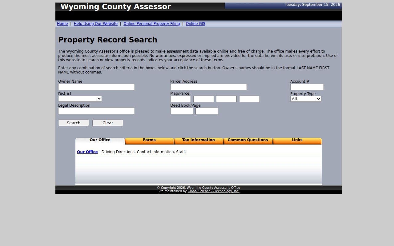
A field the local system recognizes beats a guess about how another portal stores an address. View the Assessor's official search tips for name order and street-only searching.
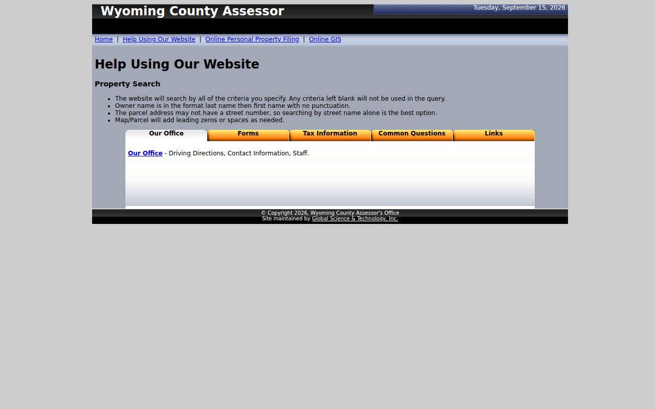
Those directions mirror the county's own matching rules and can spare you false starts in its parcel index.
Street-Only Property Search in Wyoming County
The Assessor's help notes that a street name alone may work better than an assumed street number. This matters in Wyoming County. An older parcel may lack a number there. A rural route may still be in local use, or an E-911 address may have arrived after the deed description was written. Search the road name. Read the legal description and district. Compare the card against the known location before committing to a record. The statewide WV Property Viewer relies on E-911 matching for address searches. It will not accept rural routes or P.O. boxes. A mailing address is not a second situs. It only tells you where tax notices go. A county card may list a P.O. box or an agent's address. Treat that as an owner-contact clue rather than a map location. Work the parcel search in stages. Begin with the street name when the number is uncertain. Then narrow results by the owner's last name, a known account, or the district and Map/Parcel. Blank fields are ignored, the help page says, while filled fields are combined. A misspelled road paired with an exact owner name can still return nothing. Change one clue at a time, and keep the card's legal description beside your search notes. Sometimes a rural place name is familiar but no street result appears. Use the owner or tax-map key to reach a candidate card and verify its location visually. Never assume a post-office name, ZIP, or mailing address defines the municipality. The situs, the county district, and the tax-map parcel are better checks. Consult them before you request the deed.
What a Wyoming County Search Result Shows
A county card pulls parcel identity, owner-of-record, and tax and transfer clues into one place. The field labels stay unusually plain. CURRENT OWNER and MAILING ADDRESS say exactly what they hold. A deed book and page points the way to the clerk's record. Sales History may include transfer details. But check any recorded sale price against the deed and the transfer-tax information before relying on it.
| Owner of Record | CURRENT OWNER name on the assessor card |
|---|---|
| Situs / Mailing Address | Parcel location and tax-notice destination |
| Parcel Number | Map/Parcel and account fields for local matching |
| Assessment | Land, building, total and assessment record by tax year |
| Legal Description | Lot, tract or metes-and-bounds wording |
| Last Sale | Sales-history clue and deed book/page reference, if populated |
Keep the card's limits in view. It is not a deed image, a boundary survey, or a title report. It can lag behind a new filing. The statewide map result may display one owner even when the deed lists several. The statewide assessment result for Town of Oceana illustrates how assessment and deed references sit together, showing a tax year, class, owner, owner address, book/page, legal description, and separate land, building, and total amounts.
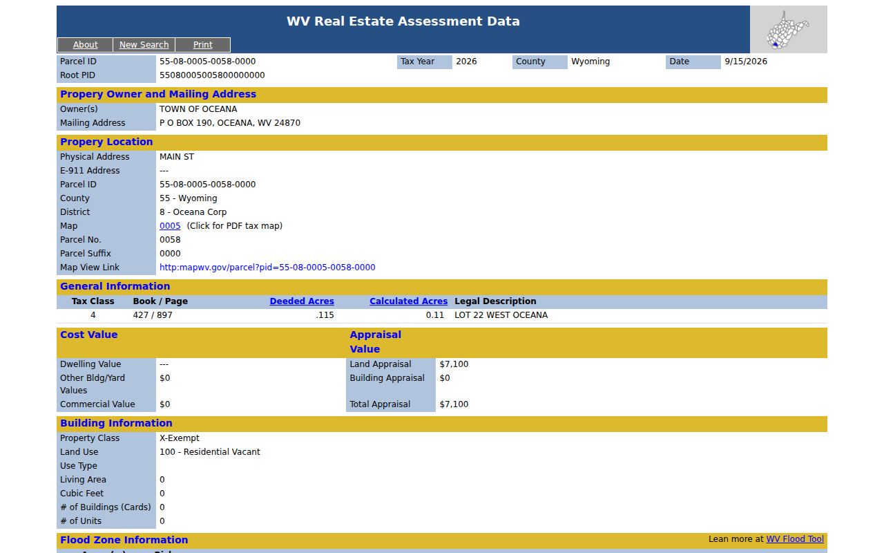
One sample result describes one public parcel. It is not a value estimate for every Oceana tract. Treat the result as a linked group of fields. The owner and mailing address identify the assessment record. The tax year and class describe the roll entry. Book and page, plus the legal description, set up the next Clerk lookup. Land, building and total values belong to that assessment year alone. They do not state a recent sale price. They do not predict what a similar parcel might fetch.
One statewide sample can show a single owner label. The recorded deed may name more than one grantee. If that distinction matters, open the referenced deed and read the whole instrument. A tax card's sales-history field offers another clue. It may not match the interest or timing in the current ownership record.
Wyoming County Search by IAS Parcel Number
The statewide viewer combines parcel data from the Integrated Assessment System, or IAS. It also draws on E-911 address data from SAMS. Its parcel identifier has district, map, parcel and suffix components. The documented format generally pads map, parcel and suffix fields to four digits. The state guide, for example, breaks a parcel into district 2. It then shows map 0011, parcel 0001 and suffix 0000. Wyoming County map ranges by municipality do not appear in that guide.
The local Assessor form is more forgiving. It can normalize spaces and leading zeros. If a statewide full-ID search misses, try the guided parts instead. Or use the local Map/Parcel fields and the account number. A parcel key is a search aid, not a deed description.
Wyoming County's local card lists district, Map/Parcel and account as distinct values. Save all three when an assessor result appears. That way a later inquiry can separate a similarly named landowner from a nearby tract. A state-viewer parcel string may carry formatted zeroes. Its suffix may also print differently on the county page.
Wyoming County Search: Deed Book and Page
When the card displays a deed book and page, record both values exactly. They point to the instrument that vested the listed owner. The County Clerk records deeds, trust deeds, releases, plats and liens. The office publishes no online deed index or image-payment process. Contact the Pineville record room with your questions. Ask whether a book can be reviewed on site, whether an image or certified copy is available, and what the current copy charge is.
A grantor conveys the interest. A grantee receives it. The deed's legal description serves better than a postal label when you trace older transfers. A parcel card speeds the search. But it cannot prove the absence of later deeds, estate filings or corrections.
Wyoming County Entity Owner Searches
A tract may be assessed to a company, trust, estate, trustee, executor or life tenant. Search the owner exactly as it appears, then try spelling and suffix variants. State business search can reveal a corporation's status, registered agent and filing address. It cannot tell you which human lives at a property. It also cannot replace the deed's vesting language. For an estate transfer, probate indexes and the land record may explain why the assessor name changed.
Use the state business database only when the assessor card identifies an entity. Its basic form searches the organization or agent/officer name. It also uses the percent sign as a wildcard. Compare any business address with the mailing address on the property card. Then return to the deed for the owner-of-record entry.
A result reading estate, trustee or executor needs more than the assessor label. That label alone will not tell you who can sign a transfer. Check the Clerk's recorded deed and any probate or fiduciary filing the county holds. When a business entity appears, the West Virginia Secretary of State's organization record can help. It can separate a registered name from a property owner's legal name. The deed still controls the land interest.
Wyoming County Property Search by Three Keys
An empty result list has a fix. The county help page suggests a street alone. It can work better than an assumed rural number. For an owner lookup, enter the last name first with no comma. Add one known parcel or account clue only if needed. A full Map/Parcel or account from a prior tax card helps. It beats a guessed ZIP or town name.
The right key depends on what you know. The County Assessor takes all three. The statewide viewer keeps its address source separate from the owner and parcel source. An empty list does not prove that no property exists. It may mean the address is rural. It may mean the name changed. It may also mean a parcel suffix was omitted.
| Search Key | Best For | Where It Works | Watch Out |
|---|---|---|---|
| Address | Find a known situs | County Assessor and state viewer | Try street-only locally; state search needs E-911 address |
| Owner name | Find listed parcels and mailing clues | County Assessor | Use LAST FIRST; check entities and same names |
| Parcel or account | Return to one mapped assessment | County Assessor and state viewer | Zeros and suffix segments may differ |
A Wyoming County property search that returns no candidate calls for fewer clues, not more. Drop one uncertain detail instead of piling on guesses. Try the street without its number. Use the owner's name in LAST FIRST order. Or search the district and Map/Parcel copied from a county map. If an older card still fails to appear, ask the Assessor whether the parcel carries another description, or whether the roll year is available through a different office channel.
Not a title search. A Wyoming County property search is a way to find public records, not a guarantee of clear title. Confirm the latest deed and seek a title professional when you need a legal conclusion.